
Advancing Flood Resilience in San Diego County Through Nature-Based Solutions
08/19/25
This article was contributed by the County of San Diego Department of Public Works – Flood Control.
The San Diego County Flood Control District (FCD), a special district governed by the County of San Diego (County) Board of Supervisors, is responsible for managing regional flood risks and maintaining flood control infrastructure in the unincorporated areas of San Diego County. It operates as part of the County’s Department of Public Works and plays a key role in supporting climate resilience efforts across the region.

FCD was awarded an Advance Assistance grant through the Federal Emergency Management Agency’s (FEMA) Hazard Mitigation Grant Program (HMGP) to evaluate the feasibility of implementing nature-based solutions to reduce flooding in the unincorporated area. This effort supports the goals of the County’s 2024 Climate Action Plan (CAP), which includes actions to enhance climate resilience through green infrastructure and stormwater management.
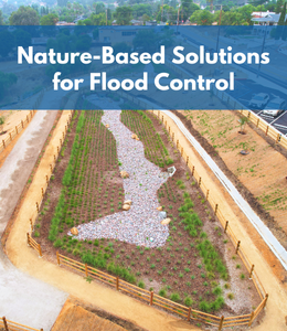
Nature-based solutions, like green infrastructure, are strategies that integrate natural features and processes into their design and function for the benefit of people and the environment. For example, biofiltration basins/channels are vegetated best management practices (BMPs) that collect, filter, and treat stormwater runoff, thereby reducing flood risk and improving water quality. They can also have other co-benefits, like increasing carbon sequestration, providing green spaces for communities, and reducing urban heat island effect. According to the Fourth Climate Change Assessment for the San Diego region, climate change is predicted to result in fewer but more intense rain events. Nature-based solutions are one way to mitigate the current and forecasted increase in flood risk.
County staff are currently working on the first of two project phases. Phase 1 identifies underserved areas with elevated flood risk, and Phase 2 will include site surveys and project design development. County staff have been identifying potential sites using numerous Geographic Information System (GIS) layers that incorporate information about location, nearby planned and existing flood control infrastructure, history of flooding and damages, social vulnerability, climate projections, and community input. Potential sites are then scored using a point system that gives priority to sites in underserved and more socially vulnerable areas, such as communities with higher poverty rates, or greater proportions of older adults or those who are disabled and may experience greater impacts from environmental hazards. Detailed scopes of work for the top scoring sites will be submitted to FEMA by May 2026 for approval before work on Phase 2 can begin.
To learn more about the County’s Flood Control section and its efforts to manage regional flood risks, please visit the program’s webpage.
