
Cottonwood Creek Project
Flood Control Grant Project - Cottonwood Creek: Project Overview
In July 2004, the County of San Diego received a grant from the
State Water Resources Control Board (SWRCB) to remove exotic
(non-native) plants and revegetate with native plants along portions
of upper Cottonwood Creek located in the Tijuana River Watershed. The
project includes two portions of Cottonwood Creek. The first portion
is approximately a two-mile stretch from Barrett Reservoir to State
Route (SR) 94 and the second extends from approximately Buckman
Springs Road to just above Morena Reservoir. Funding for the project
was provided in the form of a Proposition 13 Grant. Proposition 13 was
approved by California voters in 2000 that authorized the State of
California to sell bonds to support water resource project
funding.
 Coordination on the project
was led by the County of San Diego Department of Public
Works-Watershed Protection Program. The County contracted Rick
Engineering Company to oversee the implementation of the project as
well as provide Aerial Imagery acquisition, GPS (Global Positioning
System) field location service and Geographic Information Systems
(GIS) map production services. Additional consulting services that
were coordinated through Rick Engineering Company included Tierra
Environmental who led the aspects of the invasive removal program, and
project monitoring. RECON Environmental provided revegetation and
reporting services.
Coordination on the project
was led by the County of San Diego Department of Public
Works-Watershed Protection Program. The County contracted Rick
Engineering Company to oversee the implementation of the project as
well as provide Aerial Imagery acquisition, GPS (Global Positioning
System) field location service and Geographic Information Systems
(GIS) map production services. Additional consulting services that
were coordinated through Rick Engineering Company included Tierra
Environmental who led the aspects of the invasive removal program, and
project monitoring. RECON Environmental provided revegetation and
reporting services.
Key Components of the project
included:
1. Mapping and Planning
2. Removal and
Revegetation
3. Outreach
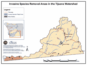 | 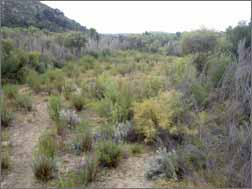 |
| Tijuana River Watershed Location Map | Cottonwood Creek Before Removal of Invasive Plants |
[ Project Overview ] [ Removal and Revegetation ] [ Outreach ]


